Drives
Vizzion’s innovative ‘Drives’ service is a source of high-density road information from on-vehicle camera imagery. The images are collected from a network of tens of thousands of connected commercial vehicles operating throughout North America, offering a comprehensive view of the roadway. Images are provided over a cellular connection, opening up new real-time use cases, like live reporting, compliance checks, and road event management. 80M+ images are captured daily, with images at key locations archived for one year, allowing users to view changes to the roadway over time and verify other data sources.
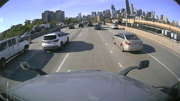
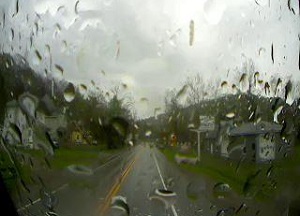
A Drive showing traffic levels, atmospheric and surface conditions, roadwork, highway signage, and more
Drives serves many use cases
Drives can be used for a variety of use cases, ranging from infrastructure monitoring and change verification, sign cataloging, and work zone detection, to adding insights to traffic reports and managing live road events, like accidents. The high-definition images are a rich source of information that provide a look into live traffic and weather conditions, pavement and lane marking conditions, roadwork, streetside-parking, incident recovery, and even driver behaviour. Without restriction, the imagery can serve as an input for training and running AI, be integrated into customer applications, and be displayed to the general public. The service can serve as ground truth, identify inaccuracies in other datasets, and replace time consuming and costly data gathering efforts, satellite imagery that’s slow to refresh, or other image sources with restrictive permissions.
How it works
Vehicles in our network provide ‘Drives data’ as they check-in with the server, typically at a frequency of every 15 seconds. This information consists of the vehicle’s location, heading, speed, timestamp, and an anonymized vehicle identifier. Vizzion stores the Drives data for for users to query using geographic and time parameters. Results matching the query are returned to the user, who can then request streams of up to 10 consecutive images from specific vehicles and times. Drives data and image streams are provided to the client via Vizzion’s RESTful API.

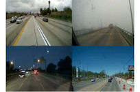
A Drive containing time, location, movement information, and current availability status
Where is the imagery available?
The commercial vehicles in Vizzion’s network travel over 2 million miles per day across North America. Comprised of a mixture of long-haul trucking fleets, local parcel delivery vans, and municipal vehicles, among others, they cover a variety of interstates, highways, other arterials, and city streets. Generally, vehicle coverage will closely reflect population density. Vizzion has tripled the number of vehicles in its network in the last year and forecasts continued growth.
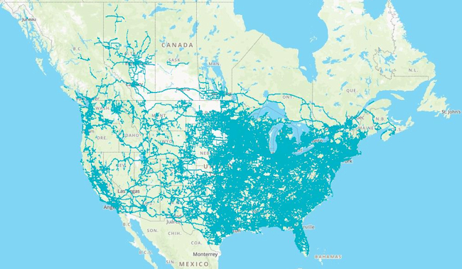
Coverage map showing 1 day of Drives in North America
Vizzion’s Commitment to Quality
Vizzion knows operators don’t want to waste time reviewing bad images, so we’ve incorporated automatic and manual processes to ensure that the images we provide are useful and free of personally identifiable information. Each camera is professionally mounted at the top of the windshield by the supplier. This prevents the camera angle from shifting and allows the viewpoint to extend overtop of the other cars on the road. Prior to its addition to the feed, each camera is manually reviewed by our team of content engineers to ensure it’s successfully providing working images of the roadway. Any vehicle not meeting our quality standards is not included. Each vehicle is reviewed on a regular basis to confirm that it’s still providing useful images. Additional processing is employed to prevent faces, license plates and other personally identifiable information from appearing in the imagery. Quality standards for the imagery and availability of the service are guaranteed by our Service Level Agreement.
Contact busdev@vizzion.com to learn how our Drives service can provide the road information you’re looking for.About Vizzion
Vizzion is the leading provider of road imagery for traffic, weather, road condition, and safety operations and applications. Through partnerships with over 200 different transport agencies and on-vehicle camera providers, Vizzion offers live feeds from over 100,000 cameras in 30+ countries across North America, Europe, Asia, Australasia, and key markets in South America and Africa. Both on-vehicle and roadside traffic camera services are available through Vizzion’s flexible API and turnkey Video Wall application. Vizzion’s content is trusted by major apps, map providers, broadcasters, fleets, and automotive organizations.Articles
Traffic Cameras: Providing the Whole Picture
Governments around the world spend millions of dollars on implementing and maintaining these traffic cameras because they know that the cameras can help mitigate traffic jams and even save lives.
Vizzion Announces New Platform Providing Massive Network of Live On-Vehicle Imagery
Vizzion's new platform will give access to on-vehicle cameras—producing live imagery as they travel.
How On-Vehicle and Roadside Cameras Work Together to Validate Road Weather Conditions
Vizzion's unique combination of roadside and on-vehicle imagery positions them as a leading provider of road condition data and surface weather conditions.
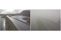
Vizzion Can Detect Areas of Low-Visibility through Image Analysis
Vizzion’s Low Visibility Detection Service scans its network of traffic cameras to detect unsafe driving conditions. The service outputs georeferenced polygons outlining locations of low visibility for use in traffic management centers and mobility apps.